 |
S.C. Beach Guide Online Help |
Welcome to the S.C. Beach Guide!
A product of the South Carolina Department of Health and Environmental Control
This application is designed to provide residents and visitors information and directions to public beach access locations and the amenities associated with those locations, and also important beach water quality information for monitoring stations proximate to access locations. With a few simple selections, you'll be able to explore over 600 public access points along South Carolina's 187 miles of Atlantic shoreline. This application is web-based and mobile device-enabled, so you can plan your trip in advance and navigate among public access sites while on your trip!
Please learn more about using this application by reading below. We hope you enjoy your next visit to the beach!
NOTE: Beach water quality monitoring for swimming advisories is ONLY performed May 1 through October 1.
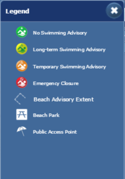
Symbology
| ||
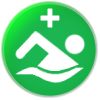
| Beach monitoring for swimming advisories is performed May 1 through October 1. Monitoring shows no swimming advisory is needed. | ||
|
||
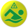
| Long-term swimming advisory signs are posted at this location. Swimming is not advised within 200 feet on either side of the sign because high bacteria levels may be present, especially following rain due to storm water runoff. Wading, fishing, and shell collecting do not present a risk. Health problems typically come from swallowing the water. See the Long-Term Swim Advisory graphic below for further explanation. | ||
| ||
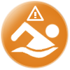
| Recent sample results indicated the area 200 feet on either side of this sign is NOT safe for swimming at this time. Sampling will continue daily until the advisory can be lifted. Wading, fishing, and shell collecting are not a risk unless you have open sores or lesions. Bacteria can get into open sores and cause infection. Health problems typically come from swallowing the water. | ||
|
||
| Beach closure due to a significant event or occurrence. | ||
| ||
| State or county beach park providing public access. | ||
|
||
| Path, walkway, walkover or ramp access to beach. |


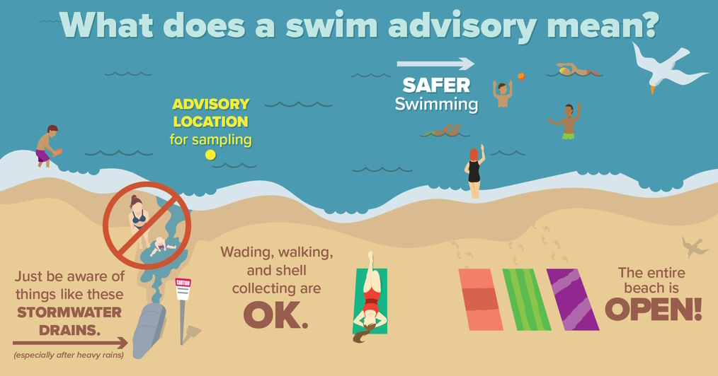
Long-Term Swim Advisory
Using the Application
The application provides several options to interact with and search for public beach access locations and review water quality data.
1.You can interact directly with the map using the map-based navigation (See the Map-Based Navigation section below) to zoom and pan to an area of interest or by choosing a beach from the Quick Navigation dropdown  on the application header. Once within the viewing area you wish to explore, simply click an access point
or monitoring station to review its details.
on the application header. Once within the viewing area you wish to explore, simply click an access point
or monitoring station to review its details.
NOTE: Quick Navigation is not available on Smart Phones.
2. You can perform a proximity search by using your current location to find beach access points near you. Click the Current Location button ![]() to find public beach access points near you. This function uses the location of your computer's IP address or your cell phone/tablet location to pinpoint your location and search for beach access points near you.
to find public beach access points near you. This function uses the location of your computer's IP address or your cell phone/tablet location to pinpoint your location and search for beach access points near you.
3.The Search tool ![]() provides two options to find access points: By Address and By Amenities.
provides two options to find access points: By Address and By Amenities.
| By Address | By Amenities | |||
| You can enter an address and the application will provide you a list of geocoded address locations that match. From the results list, you can click an address and the application performs a proximity search to find beach access points near that location. | 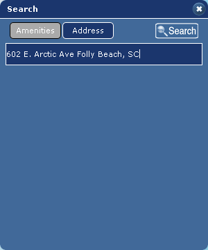 | You can search for access points based on beach, county and region, or all access points, and required amenities. The application will return access locations that match your search level and amenity selections. | 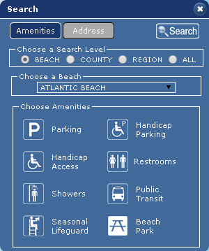 |
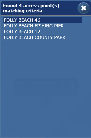
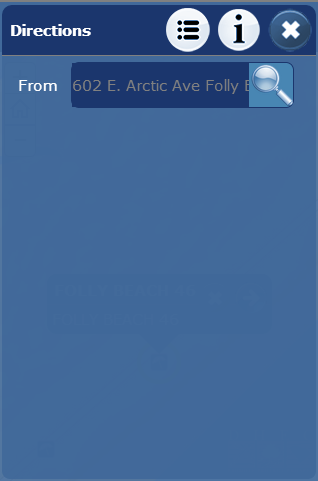
With Browsers and Tablets, proximity and amentity searches (items #2 & #3 above) return a list of beach access locations displayed in the information panel. By clicking on the individual beach access sites in the information panel list, you can see detailed information about that site as well as directions to that location.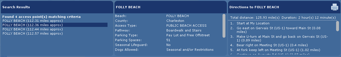
With Smart Phones, proximity and amentity searches return the first matching location, zooms to and creates a popup 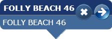 at that location. To view details of the location, click (touch) the arrow
 ![]() . To view other location results matching your criteria, click (touch) the white "list " button
. To view other location results matching your criteria, click (touch) the white "list " button ![]() . To get directions to the the location, click (touch) the white right-angle arrow button
. To get directions to the the location, click (touch) the white right-angle arrow button ![]() .
.
Smart Phone Views
| Details | Results List | Directions | Legend |
 |  |  |  |
NOTE: Choices in both the Quick Navigation and the Beach Selection component of the Amenity Search do not necessarily reflect official municipal boundaries. They represent common descriptions of geographic areas and access points are classified based on proximity to those geographic areas. For instance, an amenity search for Myrtle Beach will return all public access points within the known boundaries of the City of Myrtle Beach, but may also included access points that are proximate to the City of Myrtle Beach municipal boundary, but actually fall in unincorporate areas of Horry County. For this reason, it is quite important to review the "Authority " field within the details screen, as well as the "Rules and Guidelines " link.
Searchable Amenities
This application provides the ability to search for eight (8) specific amenities.
| Parking | Showers | ||
| Handicap Parking | Public Transit | ||
| Handicap Access | Seasonal Lifeguards | ||
| Restrooms | Beach Parks |
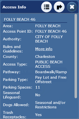
Access Point Details
This application provides information regarding certain amenities and characteristics of the access point in text format. Searchable amenities are shown as icons. The user can simply click the access point on the map to see the details in an information window.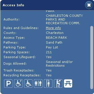
The access point details provides text-based information on pathway type, parking types, parking spaces, dog access, concessions, trash & recycling receptacles and links to the website of the administering municipality, agency or group.
NOTE: It is very important that all users of this application check the "More Info " link to review specific ordinances and rules that apply for each access site. In some cases
neighboring beach access locations may fall into different jurisdictions, and therefore, have different rules governing activities and use of the adjoining beach area.
Water Quality Details
Water quality monitoring stations are symbolized to reflect their current status. Check the Legend ![]() to review symbology. Station information and monitoring results are available by simply clicking on the stations.
to review symbology. Station information and monitoring results are available by simply clicking on the stations.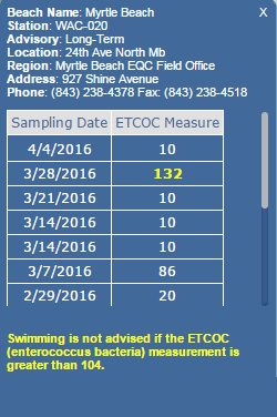
ETCOC is an abbreviation for the measurement of enterococcus bacteria in a sample of ocean water. This bacteria is the best indicator for the pathogens that may be found in ocean water.
<10 is an abbreviation for "less than 10." Ten (10) represents the detection limit for this test. Anything below 10 cannot be reliably measured, so those values are simply reported as <10.
Map-Based Navigation
There are several ways to interact with the map:
1. Use the basemap switcher![]() to select the basemap you'd like to interact with
to select the basemap you'd like to interact with
2. Hold down the shift key and drag a box on the map to zoom in
3. Hold Down Ctrl+Shift to zoom out
4. Roll your mouse roller to zoom in/out
5. Click the + or - to zoom in/out
Share Your Map
You can click on the Share Map button to share your map several different ways. You can compose an email, post to your Facebook wall or post a Tweet. When you use the Facebook or Twitter links, you'll be asked to sign in to your respective account.
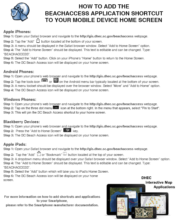
Creating a Shortcut on Mobile Device Home Screens
More Information
Should you require additional information on beach access in S.C. or have questions/comments about this application, please contact DES - BCM at 843-953-0200.
Browser Compatibility
S.C. Beach Guide is supported on the following browsers: Microsoft IE 8/9/10, Mozilla Firefox, Google Chrome and Apple Safari.
For IE, if the application does not display correctly configure the IE browser to trust the site in compatibilty view. Instructions on how to do this in the various IE versions are found in the link below.
How to fix site display problems with compatibility view.
DISCLAIMER:
The South Carolina Department of Environmental Services (SCDES) maintains this website as a service to the public. While SCDES makes every effort to provide accurate and complete information, SCDES provides no warranty, expressed or implied, as to the accuracy, reliability or completeness of furnished data.
The South Carolina Department of Environmental Services (SCDES) maintains this website as a service to the public. While SCDES makes every effort to provide accurate and complete information, SCDES provides no warranty, expressed or implied, as to the accuracy, reliability or completeness of furnished data.