Proposed Baseline and Setback Lines for Phase I (2024-2027 review cycle)
Beaches (Phase I)
Proposed Baseline and Setback line
Line Reports
Raw Data
Currently Established Baseline and Setback Lines (statewide)
Beaches
Current Baseline and Setback Line
Line Reports
Survey Packets
Links
These are links to external data sources for aerial imagery and LiDAR. SCDES BCM was not the source of these datasets, so the original sources are being provided. Additionally, at the bottom is a link and basic instructions for using ArcGIS Earth, which is a free application for viewing geospatial data.
S.C. Code Ann. § 48-39-280 requires the South Carolina Department of Environmental Services Bureau of Coastal Management (SCDES BCM or Department) to establish and periodically review two beachfront jurisdictional lines, the baseline and the setback line. The baseline is the more seaward (towards the ocean) line, while the setback line is the more landward (towards the land) line. The setback line delineates the landward extent of the state’s direct permitting authority for activities proposed within the Beach/Dune System Critical Area.
The jurisdictional lines create a state jurisdictional area where activities associated with habitable structures, pools, renourishment, landscaping, fencing, decks, service lines, and other alterations are reviewed through authorization processes to prevent unwise development and to protect resources along the beachfront. Repairs, reconstruction, and new construction of some structures are allowed under certain conditions and with proper notification to the Department as listed under S.C. Code Ann. § 48-39 and S.C. Code Ann. Regs. 30. The jurisdictional lines enable SCDES BCM to implement laws and regulations that support the state's beachfront management goals, and protect vulnerable shorelines, properties, and natural ecosystems.
Please be aware that there may be critical areas landward of the jurisdictional setback line that may also require authorization and coordination with SCDES BCM.
This web application can be used to view the approximate location of the current jurisdictional lines and download line reports and survey packets. Jurisdictional lines and basemap imagery are provided for reference purposes only. In order to determine the exact position of the jurisdictional lines for a given property, coordinates must be downloaded, and a property-specific survey must be performed.
The aerial imagery featured in this application is provided by ESRI as part of their Imagery Hybrid basemap service. Aerial imagery featured in this service is periodically updated by ESRI as new imagery becomes available (similar to the way in which Google or Bing maps are updated). A change in aerial imagery may appear as a shift in the position of the jurisdictional lines due to the angle of the aerial photography. However, the coordinates of the current jurisdictional baseline and setback line have not changed since they were established during the 2016-2018 review cycle.
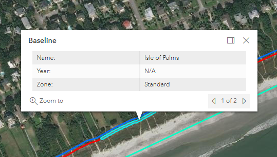
Baseline Information
When clicking on the baseline, the pop-up dialogue box will contain three items: the beach name, the source year, and the beach zone. All locations will have a beach name and the beach zone. Only unstabilized inlet erosion zones will have a source year. In unstabilized inlet erosion zones, the baseline is set at the most landward point of erosion at any time during the past forty years, unless the best available scientific and historical data of the inlet and adjacent beaches indicate that the shoreline is unlikely to return to its former position. In unstabilized inlet erosion zones, the year will indicate which shoreline was used to set the baseline.
Setback Line Information
When clicking on the setback line, the pop-up dialog box will contain two items: the beach name and the long-term erosion rate. The setback line position is dependent on the baseline position and the average long-term erosion rate, also known as the average annual erosion rate. The long-term erosion rate is calculated using current and historical shoreline data, and shoreline change software.
The setback line is established landward of the baseline a distance which is 40 times the average long-term erosion rate or not less than 20 feet.
In this viewer, the long-term erosion rates are linked to the setback line. Negative long-term erosion rate values indicate erosion and positive long-term erosion rate values indicate accretion. Users should be aware that erosional values can be associated with the minimum setback. Values of -0.5 feet per year and greater have the minimum setback of 20 feet.
Keep in mind that areas with erosional long-term rates may experience periods of accretion, and areas with accretional long-term rates may experience periods of erosion.
These rates reflect long-term trends, rather than short-term fluctuations. Property owners and developers are encouraged to consult with SCDES BCM to understand more about erosion trends and shoreline dynamics in their particular area.
For more details on the technical process, please refer to the SCDES BCM Jurisdictional Lines webpage.
How To Use This Application
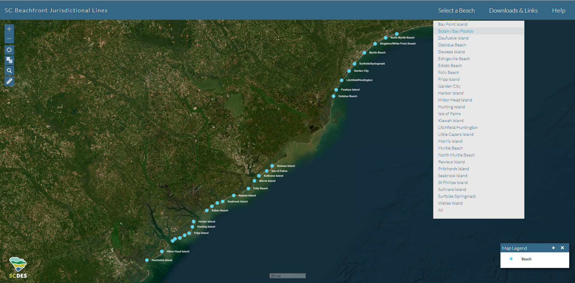
There are 3 ways to begin a search:
1. Use the ‘Select a Beach’ dropdown.
2. Select one of the blue and white ‘Beach’ points.
3. Use the Search button on the upper left side of the map to search by parcel ID or address.
Tools and Search Options
Parcel & Address Search
1. Address Search - Enter the address and city name and click the "Search" button. The applicaton geocodes (calculates the approximate location) and zooms to that location. If the address is not in a designated beach area, an alert appears. 2. Parcel Search - Enter the parcel number of the location you're interested in and click the small "Search" button. Parcel locations are only available for the immediate coastal areas. This function requires
an exact match to locate the parcel. The complete parcel number is required, with no spaces ( ), dashes (-), or periods (.).
Legend
The Legend tool allows the user to understand what features on the map represent. The legend appears on the lower panel of the application. It can be scrolled vertically to expose hidden legend items. It can also be scrolled horizontally for use on smaller screens.
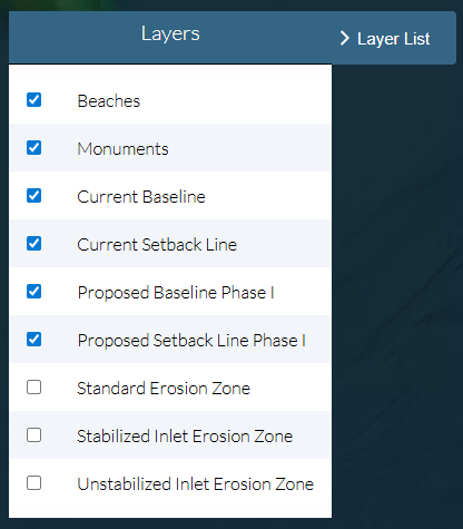
Layer List
The Layers button, located on the map interface, provides access to a list of available operational layers and their corresponding symbols. Clicking this button will toggle the display of the Layers panel, allowing you to manage map content.
Using the Layers Panel
Show/Hide Layers: Each layer in the list has a checkbox. To turn a layer on or off, simply check or uncheck the box next to its name.
Layer Ordering: The order of layers in the list determines their drawing order on the map.
This tool allows for complete customization of the map display, enabling you to focus on the specific data that is most relevant to your needs.
Popup Window
The "popup" window is "on" by default when zoomed into a beach area. The "popup" window is used to display important fields or information about a selected feature. Simply click a map feature (pointer cursor
will appear when hovering over a feature is "selectable"). When a feature is selected it is highlighted in light blue & details of the feature appear in the "popup" window.
The more "zoomed-in" the more precise the feature selection will be. If zoomed-out or if features lie in close proximity, multiple features will be captured in the "popup" window. The user can iterate through
the selected features using the small pointer arrow at the bottom-right of the "popup" window.
Measure
The Measurement widget
provides three tools:
1. Area Measure – This tool allows the user to create a polygon and calculate the area in a variety of units (square miles, acres, square kilometers, etc.). To use this tool, click on the map to create points that represent the boundary of a polygon. When the boundary is defined, double click to complete the operation.
2. Distance Measure – This tool allows the user to create lines/polylines and calculate the length in a variety of units (miles, feet, kilometers, etc.). To use this tool, click on the map to create points that represent the beginning and end of a line. When the line points are defined, double click to complete the operation.
3. Clear – This tool allows the user to delete current graphics on the map and clear the measurement window.
Basemap
The Basemap Toggle allows the user to switch between ESRI-provided basemap services - Satellite imagery & street map.
Downloads and Links
Download current and proposed baseline and setback line GIS data in ESRI® shapefile format, by beach, under the Downloads and Links section. Raw data associated with the proposed lines, and survey packets (containing DWG and Excel coordinate files) associated with the current lines are also available for download under this section. Line reports, by beach, can be downloaded in PDF format here, as well.
The Downloads and Links section also includes links to external data sources for aerial imagery and LiDAR.
The South Carolina Department of Environmental Services Bureau of Coastal Management (SCDES BCM) is required by law to establish and periodically review two beachfront jurisdictional lines, the baseline and the setback line, every seven to ten years.
The jurisdictional lines create a state jurisdictional area where activities associated with habitable structures, pools, renourishment, landscaping, fencing, decks, service lines, and other alterations are reviewed through authorization processes to prevent unwise development and to protect resources along the beachfront. Repairs, reconstruction, and new construction of some structures are allowed under certain conditions and with proper notification to the Department as listed under S.C. Code Ann. § 48-39 and S.C. Code Ann. Regs. 30. The jurisdictional lines enable SCDES BCM to implement laws and regulations that support the state's beachfront management goals, and protect vulnerable shorelines, properties, and natural ecosystems.
Aerial imagery featured in this application is provided by ESRI and periodically updated by ESRI as new imagery becomes available (similar to the way in which Google or Bing maps are updated). A change in aerial imagery may appear as a shift in the position of the jurisdictional lines due to the angle of the photography. However, the coordinates of the current established baseline and setback line have not changed since they were established during the 2016-2018 review cycle.
The new cycle, 2024 – 2027, was announced in January 2024. Proposed baselines and setback lines, as well as line reports, are now available for Phase I beaches.
For additional information on beachfront jurisdiction and the 2024-2027 review cycle,please visit the
State Beachfront Jurisdiction page.


 will appear when hovering over a feature is "selectable"). When a feature is selected it is highlighted in light blue & details of the feature appear in the "popup" window.
The more "zoomed-in" the more precise the feature selection will be. If zoomed-out or if features lie in close proximity, multiple features will be captured in the "popup" window. The user can iterate through
the selected features using the small pointer arrow at the bottom-right of the "popup" window.
will appear when hovering over a feature is "selectable"). When a feature is selected it is highlighted in light blue & details of the feature appear in the "popup" window.
The more "zoomed-in" the more precise the feature selection will be. If zoomed-out or if features lie in close proximity, multiple features will be captured in the "popup" window. The user can iterate through
the selected features using the small pointer arrow at the bottom-right of the "popup" window.
 allows the user to switch between ESRI-provided basemap services - Satellite imagery & street map.